Journal Of Goverment Audit and Accounts

 ISSUE - July 2024
Accessibility of Cutting-Edge Technologies in GIS and RS By Mr. Virender Kulharia, Director
The democratization of cutting-edge technologies such as Geographic Information Systems (GIS) and Remote Sensing stands as a huge shift, empowering auditors of all backgrounds and resources, levelling the playing field. The accessibility of these transformative tools is ushering in a new era of innovation in auditing landscape.
Traditionally, the adoption of advanced technologies in auditing was hampered by several barriers, including exorbitant costs, complex implementation processes, and requirements of specialized technical expertise. However, in recent years, these barriers have been dismantled, paving the way for widespread adoption and utilization. The cost of entry into the domain of GIS and Remote Sensing has plummeted, due to the proliferation of open-source software and cloud-based platforms. We no longer face prohibitive licensing fees or equipment costs to harness the power of these technologies.
User-friendly interfaces and compatibility with retail laptops and smartphones have made GIS and Remote Sensing tools accessible to individuals with varying levels of technical proficiency. Open-source platforms such as QGIS, free remote sensing software such as Google Earth Desktop, and freely available high-quality remote sensing data such as Landsat and Sentinel satellite datasets, offer robust functionalities without steep learning curves & sophisticated spatial analysis capabilities with minimal training.
Landsat Collection 2 data and science products are freely available for viewing and download from EarthExplorer, LandsatLook, and GloVis. Collection 2 data can also be accessed from the Amazon Web Services (AWS) cloud platform. Similarly, Copernicus Programme of the European Union’s Space programme, offers Copernicus Data Space Ecosystem, which offers immediate access to enormous amounts of open and free Earth observation data from the Copernicus Sentinel satellites, including new and historical Sentinel images, and Copernicus Contributing Missions.
The proliferation of affordable drones equipped with high-resolution cameras has democratized aerial imagery acquisition and enables us to conduct joint inspections in inaccessible areas such as vast industrial areas, waste sites, or thick forests without the need for costly aircraft or satellite imagery subscriptions.
In the above context, INTOSAI WGEA came out with “Training Tool on Environmental Data: Resources and Options for Supreme Audit Institutions”. The Training Tool was developed by SAI India (leader) and SAI USA (member). Module 3.2.0 in the training tool details some of the high-quality open-source data available freely for audit purposes. Our institution also brought out Guidance Note on usage of Remote Sensing Data and Geographic Information System for effective audits.
A prototype e-Learning module on “Use of Remote Sensing and Geographical Information System (GIS) in Audit” was developed. The video content for the course has been hosted on YouTube and can be accessed directly at this link. The module has videos with length ranging from 39 Seconds to 14 minutes and has a mix of theory and practical hands-on training. In some of the videos, natural-sounding speech has been synthesized using Text-to-Speech tools.
Our institution must embrace the accessibility of GIS and Remote Sensing technologies and integrate them in our audit processes driving accountability and transparency in every audit.
Continue Reading

From the Editor's Desk
Forty years ago, recognising the knowledge driven nature of our Institution, the quarterly publication of the “Journal of Management and Training” was initiated....

Reporting for impact - Improving readability of audit reports
The need for enhancing the value and impact of CAG’s audit has been an enduring concern...

Application of Machine Learning Algorithms in Audit
There has been a tremendous explosion of data available with public sector entities over the last 20 years...

Digital Accountability: Harnessing Photo Forensics for e-Services Audits
In an era where technology intertwines with governance, the shift towards online portals for delivering public services has been monumental...

Beneficiaries of Social Schemes and Assessment
Social programmes have evolved over the decades, aiming for increased coverage, higher entitlements, and better design by using technology for targeting...

Blue Carbon Accounting
Human beings thrive in diverse ecosystems but often simplify these ecosystems over time. This simplification occurs through targets...

Generative AI: The Age of Artificial Imagination
In the vast landscape of artificial intelligence, few innovations have captured the imagination of the humans and sparked as much excitement as...

A 1.5-year-old DAG in a 150-year-old Institution
It was on 14th December 2022 when our posting orders came while I was still attached as an Assistant Director in the CRA Wing in the Headquarters Office, New Delhi....

Water Resource Accounting in India
Water: The word itself is an indication of life on the planet. About 60% of the human body contains water...
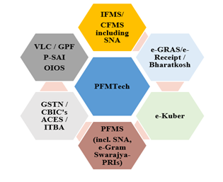
Emerging PFMTech ecosystem and the Accounting and Auditing functions
Accounting and auditing, an integral part of Public Financial Management (PFM) cycle...